Methods of ImaGeo Corescanning and a case study of a high resolution borehole evaluation from the Mecsek mountains
Abstract
The self developed ImaGeo system allows the construction of 3D geotectonic models through the collection of high resolution digital geological data in the field, in drillings and mines. The images and data can be obtained both in normal and UV light. The data can be oriented using geophysical borehole logging (acoustic Borehole televiewer BHTV, or microresistivity measurer Formation Microimager, FMI) to their original position, thus making detailed geological evaluations possible in real space. The system consists of the Corescanner, the Photorobot and the Laser Induced Plasm Spectrometer.
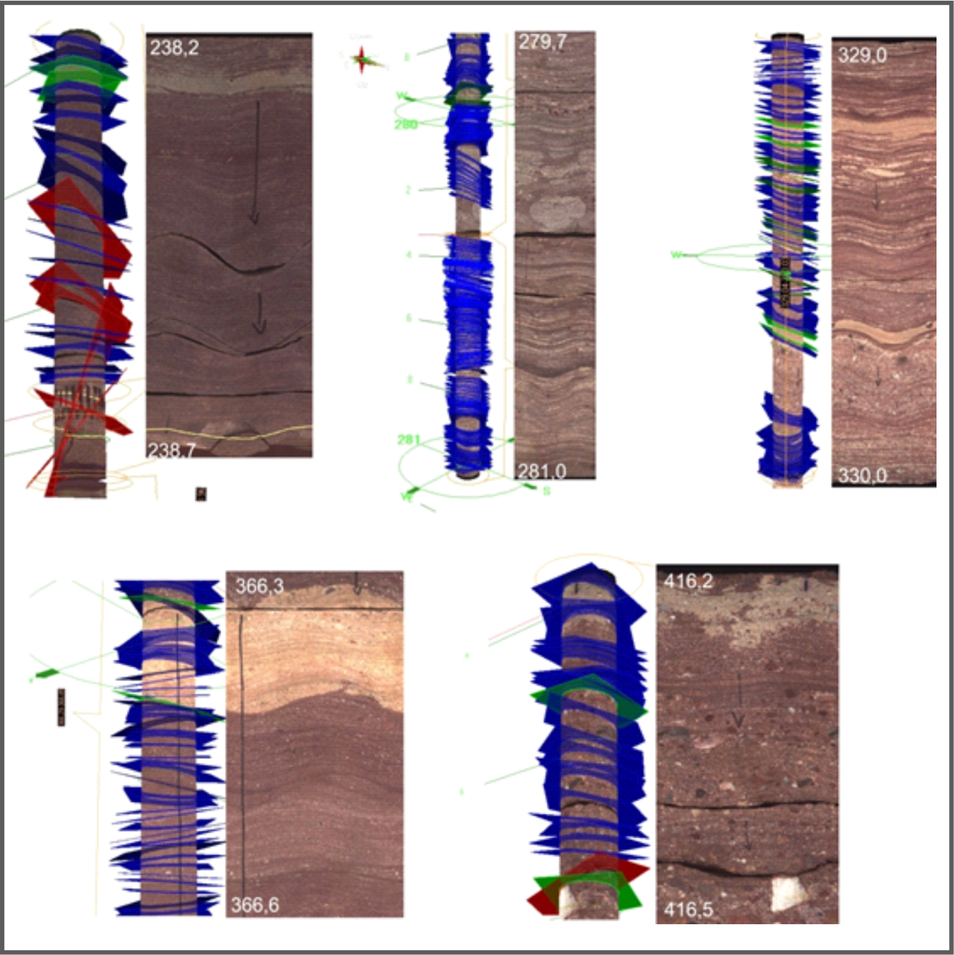
This paper describes a case study on the core scanning result of the Mesozoic succession in borehole Ibafa, Ib–4, with special emphasis on the Jakabhegy Sandstone Formation, besides introducing the methods used in the ImaGeo system. The examination of the Jakabhegy Formation was carried out after back-rotating the data in order to remove the structural tilt of 45/13° (dip direction/dip angle) to its original position. The succession of the Jakabhegy Formation could be divided into five elaborately analyzed sections in terms of grain size, lamination thickness, dip direction and dip angle data deriving from the corescanning. The sections do not correlate with the sections determined by the geological documentation. The back-rotated dip direction data show SSE, S and SW orientation with certain sections dipping also to the W or E. These are interpreted as the major transport directions. The transport directions show wide variety throughout the whole formation. The cycle analysis of the lamination thickness, dip direction and dip angle data was carried out by visually observing patterns, and also by periodicity analysis, We managed to define multiscale cyclicity patterns. Decimetres, 1, 3 and 8 metres cycles could be defined by the distribution of dip direction data, while dip angles indicate 0.5 metre cyclicity with both methods. The periodicity analysis defined 1.3 and roughly 4.5 metres parallel cycles in the dip directions and dip angles. The visual analysis determined a cycle as long as about 50 metres, which could not been verified by the periodicity analysis.
References
Andrássy L., Maros Gy. 2011: A Bodai Aleurolit Formációban mért ImaGeo–LIPS elemoxidkoncentráció-értékek eloszlásának statisztikai vizsgálata (Bakonya, Bak–5 fúrás) — Magyar Geofizika, 52/2. pp. 62-78.
Andrássy, L., Németh, B., Vihar, L. 1998: Theoretical and Practical Problems, of the Application of Laser-Induced Plasma Emission Spectroscopy in Geological Prospecting OPTICA’98. 5th Congress of Modern Optics, Prceedings of SPIE, Vol. 3573, pp. 351-354. https://doi.org/10.1117/12.320963
Andrássy, L., Zilahi-Sebess, L., Vihar, L. 2003: Theoretical and statistical investigation of elemental concentration distributions determined by laser-induced atom emission spectra on geological samples – Geophysical Transaction 44/2, pp. 95-138.
Balla, Z., Gyalog, L., 2009: Geology of the north-eastern part of the Mórágy Block. Explanatory notes to the geological map-series of the north-eastern part of the Mórágy Block (1:10,000). Regional map series of Hungary. — Geological Institute of Hungary, 2009, 216 p.
Barabás, A. – Barabás-Stuhl, Á. 2005. Geology of the Lower Triassic Jakabhegy Sandstone Formation, Hungary, SE Transdanubia. Acta Geologica Hungarica, 48 (1), pp. 1-47.
Barabásné Stuhl Á. 1967: Jelentés a mecsekhegységi felsőpermi üledékek ciklusos üledékképződéséről — Kézirat, J0085 Mecsekérc Adattár, 27 p.
Barabásné Stuhl Á. 1979: Mikroflóra vizsgálatok a mecsek-hegységi perm és alsó-triász üledékekben, különös tekintettel a perm-triász időszakok közötti határ kérdésére. — Kézirat, Mecsekérc adattár
Barabásné Stuhl Á. 1993: A Jakabhegyi Homokkő Formáció in Haas J. (ed.) Magyarország litsztratigráfiai alapegységei — Magyar Állami Földtani Intézet, 278. p.
Benedek, K., Bőthi, Z., Mező, Gy., Molnár, P. 2009: Compartmented flow at the Bátaapáti site in Hungary. — Hydrogeology Journal 17 (5), pp. 1219–1232.
Böckh J. 1976: Pécs város környékének földtani és vízi viszonyai — Földtani Intézet Évkönyve 4. pp. 150-328.
Bunn, A. G. 2008: A dendrochronology program library in R (dplR), Dendrochronologia, 26, 115–124,. https://doi.org/10.1016/j.dendro.2008.01.002
Chikán G., Chikán Gné, Kókai A. 1984: A Nyugati-Mecsek földtani térképe. 1:25 000. – Magyar Állami Földtani Intézet, Budapest
Chikán G., Konrád Gy. 1982: A Nyugat-Mecseki földtani térképezés újabb eredményei. – A Magyar Állami Földtani Intézet Évi Jelentése 1980-ról, 169–186.
Cooley, J. W. – Tukey, J.W., 1965.: An algorithm for the machine calculation of complex Fourier series, Math. Comput. 19: pp. 297–301.
Csicsák J. 1988: A Jakabhegyi Homokkő Formáció „átmeneti rétegeinek” kőzettan-geokémiai vizsgálata — Szakdolgozat, ELTE,
Gyalog L., Füri J., Borsody J., Maros Gy., Pásztor Sz. 2010: Geological Mapping of the Bátaapáti Tunnels (A bátaapáti vágatok földtani dokumentálása) — A Magyar Állami Földtani Intézet Évi Jelentése, 2009 pp. 305-329.
Haas, J. – Péró, CS. 2004: Mesozoic evolution of the Tisza Mega-unit. International Journal of Earth Sciences 93, pp. 297–313. https://doi.org/10.1007/s00531-004-0384-9
Halász A. 2011: A Bodai Aleurolit Formáció ciklussztratigráfiai vizsgálata PhD Doktori értekezés, Pécsi Tudományegyetem, 129 p.
Hatvani, I. G., Kern, Z., Leél-Őssy, S., & Demény, A. (2018). Speleothem stable isotope records for east-central Europe: resampling sedimentary proxy records to obtain evenly spaced time series with spectral guidance. Earth System Science Data, 10(1), 139-149. https://doi.org/10.5194/essd-10-139-2018
Hámos G., Sámson M., Bernáth Gy., Csurgó G., Darvas K., Konrád Gy., Kovács A. Cs., Kovács L., Krupa Á., Ludmann L., Maros Gy., Máthé Z., Rőczei N., Somodi G., Szegő I. 2017: Ib–4 fúrás dokumentáló és értékelő jelentése, — Kézirat, RHK-N-004/17, RHK Kft. Adattár, Paks, 228 p.
Holzkämper, S., Mangini, A., Spötl, C., and Mudelsee, M. 2004: Tim- ing and progression of the Last Interglacial derived from a high alpine stalagmite, Geophys. Res. Lett., 31, L07201. https://doi.org/10.1029/2003gl019112
Kassai M. 1969: A Jakabhegyi homokkőöszlet fácies- és korkérdései — Doktori értekezés, MÁFI
Kassai M. 1973: A délkelet-dunántúli paleozóos rétegsorok fáciesmeghatározásának problémái — Földtani Közlöny 103., pp. 383-402.
Kassai M. 1984: The Jakabhegy Sandstone Formation and its interregional stratigraphic relations — Acta Geol. Hung. 27(3-4), pp. 289-293.
Kereszturi, Á., Duvet, L., Gróf, Gy., Gyenis, Á., Gyenis, T., Kapui, Zs., Kovács, B., Maros, Gy. 2019: Characterization and first results of the planetary borehole-wall imager — methods to develop for in-situ exploration Open Astronomy 28/1 Published Online: 2019-03-26. | DOI: https://doi.org/10.1515/astro-2019-0001
Konrád Gy. 1997: A DK-Dunántúl alsó- és középső-triász képződmények szedimentológiai vizsgálatának eredményei — Kandidátusi értekezés, 119 p.
Konrád Gy., Sebe K., Halász A., Halmai Á. 2010: A Délkelet-Dunántúl földtani fejlődéstörténete – recens analógiák — Földrajzi Közlemények 134. 3. pp. 251-265.
Kovács, J., Szabó, P., Szalai, J. (2004):Talajvízállás adatok idősoros vizsgálatai a Duna – Tisza közén –Vízügyi Közlemények 86 : 3-4 pp. 607-624. , 18 p.
Kovács, J, Kiszely-Peres, B, Szalai, J, Kovácsné, Székely I. (2010): Periodicity in shallow groundwater level fluctuation time series on the Trans-Tisza Region, Hungary, Acta Geographica AC Geologica et Meteorologica Debrecina 4-5 pp. 65-70. , 6 p.
Kulander, B.R., Dean S. L., Ward B. J.: 1990: Fractured Core Analysis: Interpretation, Logging, and Use of Natural and Induced Fractures in Core — AAPG Methods in Exploration series No. 8., 88 p. https://doi.org/10.1306/99a4d0a5-3318-11d7-8649000102c1865d
Lomb, N.R., 1976.: Least-squares frequency analysis of unequally spaced data. Astrophysics and Space Science, 39, pp. 447-462. https://doi.org/10.1007/bf00648343
Mader, D. 1992: Evolution of Paleoecology and Paleoenvironment of Permian and Triassic Fluvial Basins in Europe. Gustav Fischer Verlag, Stuttgart, New York, 852. p.
Maros, Gy., Palotás, K. 2000: Evaluation of planar features in Boreholes Üveghuta Üh–22 and Üh–23 with CoreDump software (Az üveghutai Üh–22 és Üh–23 fúrásban észlelt síkszerű jelenségek értékelése CoreDump szoftverrel) — A Magyar Állami Földtani Intézet Évi Jelentése 1999-ről, pp. 315–340.
Maros, Gy. and Pásztor, Sz. 2001: New and oriented core evaluation method: ImaGeo — European Geologist No. 12., pp. 40–43.
Maros Gy., Gróf Gy., Gyenis Á., Pásztor Sz., Palotás K. 2006: Új módszer a bányatérségek földtani–tektonikai–vízföldtani dokumentálásában (New method in the geologic–tectonic–hydrogeologic documentation of shefts and tunnels) — Abstract, VIII. EMT Bányászati, kohászati és földtani konferencia, Sepsiszentgyörgy 2006 április, p. 253.
Maros, Gy., Andrássy, L., Zilahi Sebess, L., Máthé, Z. 2008: Modelling the Boda Aleurolite Formation (BAF) based on core analyses using a laser-induced plasma spectrometer — First Break, Vol. 26. pp. 143-152.
Nelson, R.A., Lenox, L.C., Ward, B.J., JR., 1987, Oriented core: Its use, Error and Uncertainty: American Association of Petroleum Geologists, Bulletin, v. 71, p. 357–367. https://doi.org/10.1306/94886eb1-1704-11d7-8645000102c1865d
Özkaya, S.I. 2019: Fracture modeling from borehole image logs and water invasion in carbonate reservoirs with layer-bound fractures and fracture corridors — Journal of Petroleum Science and Engineering, 179, pp. 199-209., https://doi.org/10.1016/j.petrol.2019.04.052
Parti G. 1986: A Jakabhegyi Homokkő Formáció tavi rétegeinek kőzettani- geokémiai vizsgálata. — Szakdolgozat.
Paulsen, T.S., Wilson, T.J., Moos, D., Jarrard, R.D., Wilson, G.S. 2000: Orientation of CRP-2A Core, Victoria Land Basin, Antarctica — Terra Antarctica 7/3. pp. 271-278.
Paulsen, T.S., Jarrard, R.D., Wilson, T.J. 2002: A simple method for orienting drill core by correlating features in whole-core scans and oriented borehole-wall imagery — Journal of Structural Geology 24., pp. 1233-1238. https://doi.org/10.1016/s0191-8141(01)00133-x
Payenberg, T.H.D., Lang, S.C., Koch, R. 2000: A simple method for orienting conventional core using microresistivity (fms) images and a mechanical goniometer to measure directional structures on cores — Journal of Sedimentary Research, 70/2, pp. 419–422. https://doi.org/10.1306/d4268c16-2b26-11d7-8648000102c1865d
Potts, G.J., Reddy, S.M. 1999: Construction and systematic assessment of relative deformation histories — Journal of Structural Geology 21, pp. 1245-1253. https://doi.org/10.1016/s0191-8141(99)00036-x
R Core Team: R: A Language and Environment for Statistical Com- puting, R Foundation for Statistical Computing, Vienna, Austria, 2018.
Rider, M., Kennedy, M. 2011: The Geological Interpretation of Well Logs. Rider-French Consulting Ltd., Scotland, 432 p.
Scargle, J. D. (1982). Studies in astronomical time series analysis. II - Statistical aspects of spectral analysis of unevenly spaced data. Astrophysical Journal. 263: 835. https://doi.org/10.1086/160554
Schmidt, P.W. and Anderson, J.C. (1992), ‘Orientation of drill core using palaeomaqnetism in coal exploration’, Australian Coal Geology 8, 18–20.
Schulz, M. and Mudelsee, M.: REDFIT: estimating red-noise spec- tra directly from unevenly spaced paleoclimatic time series, Comput. Geosci., 28, 421–426. https://doi.org/10.1016/s0098-3004(01)00044-9
Szabó J. 1965: A mecseki felső permi és alsó szeizi rétegek ferderétegzettségi adatainak földtani értékelése — Földtani Közlöny 95.1, pp. 40-46.
Toropainen, V. 2010: Core Drilling of Drillhole ONK-PVA8 in ONKALO at Olkiluoto 2010 — Kézirat, Posiva OY Olkiluoto, Working Report 2010-84, 34 p.
Vágó Z. 1980: A Jakabhegyi Homokkő Formáció leírása és fáciesének meghatározása üledékföldtani vizsgálatok alapján — Kézirat, Mecsekérc adattár, Diplomaterv, 57 p.
Vadász E. 1935: A Mecsekhegység. Magyar tájak földtani leírása — A Magyar Királyi Földtani Intézet kiadványa, 180 p.
Weber, H. 1994: Analyse geologischer Structuren mit einem Bohrkernscanner (Analysis of geological structures using the DMT Corescan mashine) Felsbau 12. Pp. 401-403.
Wyllie, D.C., Mah, C.W. 2005: Rock slope engineering civil and mining — Spon Press, London, 430 p.
Zemanek, J., Glenn, E.E., Norton L.J., Caldwell, R.L. 1970: Formation evaluation by inspection with the borehole televiewer. Geophysics 35. Pp. 254-269. https://doi.org/10.1190/1.1440089
Zilahi-Sebess, L., Mészáros, F., Szongoth, G. 2000: Characterisation of fracture zones in granite, based on well-logging data at the Üveghuta Site (A gránit töréses öveinek jellemzése mélyfúrás-geofizikai adatok alapján az üveghutai telephelyen). — A Magyar Állami Földtani Intézet Évi Jelentése 1999-ről, pp. 253–272.