Significance of the reflection seismic methods in the non-hydrocarbon explorations in Hungary — Case studies from the the Mining and Geological Survey of Hungary and its predecessors
Abstract
Applied seismic research at the Mining and Geological Survey of Hungary follows the tradition of the Eötvös Loránd Geophysical Institute in conformity with the recent demands. Utilizing the joint interpretation of archive geoscience data and modern seismic results, the risk of geological investigations can be efficiently reduced and the obtained geological model contributes to the success of innovation projects connected with the geological environment. The highest uncertainty in those projects (e.g. exploitation of natural resources, waste deposition, or construction geology) is the delimitation of the geological formations and characterization of their petrophysical properties and inhomogeneities. If only point-like borehole data was used for mapping, the above tasks would be performed only with a high level of uncertainty.
In this paper, three case studies are presented from Hungary. The results demonstrate the benefits of the seismic investigations in decreasing the geological uncertainty at a significantly lower cost compared to the total cost of the entire project.
The requirement for establishing the proposed high-activity radioactive waste depository in the Western Mecsek Mountains is that the target geological formation, the Boda Claystone Formation (BCF), must correspond with strictly specified parameters (e.g. extent, thickness, and spatial position). Based on the new seismic results, the range of BCF can be extended to the west, the structural lineaments articulating the study area were refined, and also the significance of the intensive movements in the Miocene was verified.
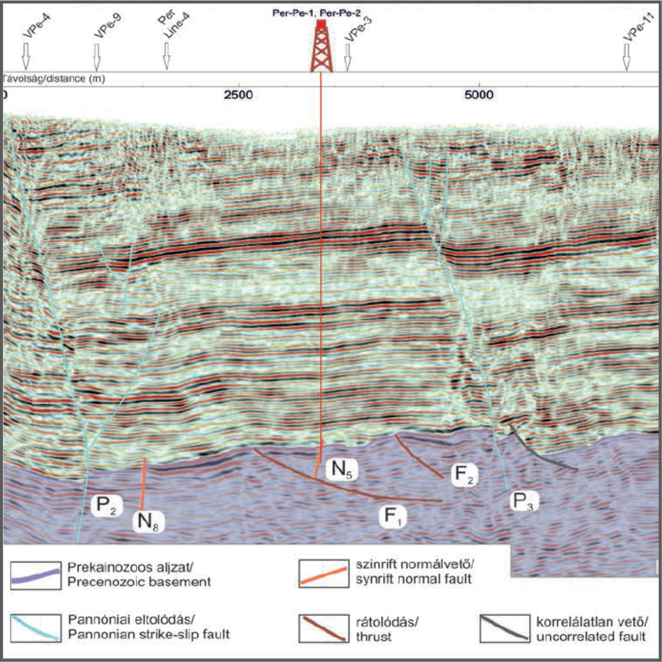
The production and injection wells of the Geothermal Project of the city of Győr were located based on a multi-step seismic survey carried out around the villages of Pér and Bőny. The key for the cost-effectiveness of the project, regarding the geological setting of the area (fractured, karstic carbonate water reservoir), was mapping of the deep and laterally narrow fault zones with a proper permeability. High-resolution 2D and 3D surveys provided detailed structural information for the determination of the optimal locations of the wells.
The most unknown geological features of the Western Borsod Coal Province, around the village of Sajómercse, are the faults representing the highest risk from geological viewpoint. A new shallow seismic survey performed in 2019 verified the existence of the faults assigned by high-resolution well log correlations, and the kinematics of the faults was also clarified: the seismic sections basically show compressional tectonics in the study area. In addition, several earlier unknown smaller faults were detected with a comparable extension to the thickness of coal seams.
References
ALEARDI, M. & MAZZOTTI, A. 2012: A study on the seismic AVO signatures of deep fractured geothermal reservoirs in an intrusive basement. – EGU General Assembly, Geophysical Research Abstracts 14, p. 3043.
ÁDÁM L. 2006: A Darnó-öv hatása a borsodi széntelepes összletre. – Földtani Közlöny 136/1, 25–36.
ÁDÁM L. 2014: A borsodi kőszéntelepes összlet rétegtani problémái. – Általános Földtani Szemle 31, 33—50.
BAUER M., CSERKÉSZ-NAGY Á. & TAKÁCS E. (szerk.) 2019: Kutatási jelentés a Sajómercse–Sajóvelezd, valamint Uppony–Bánhorváti térségében elvégzett szeizmikus mérésről. – Jelentés, MBFSZ, Budapest, 62 p.
BEKE B., FODOR L., MILLAR, L., PETRIK A. 2019: Deformation band formation as a function of progressive burial: Depth calibration and mechanism change in the Pannonian Basin (Hungary). – Marine and Petroleum Geology 105, 1–16. https://doi.org/10.1016/j.marpetgeo.2019.04.006
BODOKY T. & POLCZ I. 2016: Az Eötvös Lóránd Geofizikai Intézet története II. – MFGI, Budapest, 726 p.
BOHNNÉ HAVAS, M., NAGY, E., NAGY-BODOR, E., RADÓCZ, GY., RÁKOSI, L., SZEGŐ, É. (2000): Paleoenvironmental reconstruction of cyclic coal-bearing sequence in Borsod basin (N. Hungary). – Geological Society of Greece, Spec. Publ. 9, 37–42.
CAMELI, G. M., CECCARELLI, A., DINI, I. & MAZZOTTI, A. 2000: Contribution of the seismic reflection method to the location of deep fractured levels in the geothermal fields of southern Tuscany (Central Italy). – World Geothermal Congress, Proceedings, 1025–1029.
CHOPRA, S. & CASTAGNA, J. P. 2014: AVO. – Investigations in Geophysics, 16, Society of Exploration Geophysicist, Tulsa, Oklahoma, 288 p. https://doi.org/10.1190/1.9781560803201
CSERKÉSZ-NAGY Á., TAKÁCS E., BAUER M., CSABAFI M., GÚTHY T., KÓBORNÉ BUJDOSÓ É., KOVÁCS A.CS., SZŐTS G. & HEGEDŰS E. 2018: A Nyugat-Mecsek szeizmikus kutatásának legújabb eredményei: A Me-105 és Me-106 szelvények földtani értelmezése. – In: HÁMOS G. & SÁMSON M. (szerk.): Bodai Agyagkő Formáció kutatás szakmai előadói nap. – Magyarhoni Földtani Társulat, MTA Pécsi Akadémiai Bizottság, RHK Kft. kiadvány, Pécs, 72–80.
FANCSIK T., TÓTH S., GYÖRGY L., NYÁRI ZS., 2010. Archív ELGI szeizmikus szelvények feldolgozása, értelmezése. – Kutatási jelentés, Kézirat, ELGI, Budapest.
FODOR L. 2010: Mezozoos-kainozoos feszültségmezők és törésrendszerek a Pannonmedence ÉNy-i részén – módszertani és szerkezeti elemzés. – Akadémiai doktori értekezés, Magyar Tudományos Akadémia, Budapest, 129 p.
FODOR, L., RADÓCZ, GY., SZTANÓ, O., KOROKNAI, B., CSONTOS, L. & HARANGI, SZ. 2005: Post-Conference Excursion: Tectonics, Sedimentation and Magmatism along the Darnó Zone. – GeoLines, 19, 142–162 p.
GÖNZ G. & RÁDLER B. 1985: A vertikális szeizmikus szelvényezés (VSP) alapjai. – Magyar Geofizika 26/2, 43–53.
GYALOG L. (szerk.) 2013: Magyarország földtani térképe 1:500000. – MFGI, Budapest.
HAAS J., BUDAI T., CSONTOS L., FODOR L. & KONRÁD Gy. 2010: Magyarország pre-kainozoos földtani térképe 1:500000. – MÁFI, Budapest.
HEGEDŰS E. 1984: Jelentés a Felsőnyárád és Dubicsány térségben végzett reflexiós szeizmikus és elektromágneses mérésekről. – Jelentés, MÁELGI, Budapest, 16 p.
HORVÁTH J., HÁMOS G., BENŐ D., MENYHEI L., SÁMSON M., SZAMOS I., HALÁSZ A., KONRÁD GY. 2018: A BAF kutatási terület földtani-szerkezeti alapvonásai. In: HÁMOS G. & SÁMSON M. (szerk.): Bodai Agyagkő Formáció kutatás szakmai előadói nap. – Magyarhoni Földtani Társulat, MTA Pécsi Akadémiai Bizottság, RHK Kft. kiadvány, Pécs, 81–87.
JÄGER, R., MANN, J., HÖCHT, G. & HUBRAL, P. 2001: Common-reflection-surface stack: image and attributes. – Geophysics 66, 97–109. http://dx.doi.org/10.1190/1.1444927
KISS J. (szerk.) 2003: Kutatási jelentés a BAF 2003 projekt keretében végzett gravitációs és mágneses mérések kivitelezéséről és értékeléséről. – Jelentés, ELGI, Budapest.
KONRÁD GY., SEBE K. 2010: Fiatal tektonikai jelenségek új észlelései a Nyugat-Mecsekben és környezetében. – Földtani Közlöny 140/2, 135–162.
KONRÁD GY., SEBE K. & BUDAI T. 2016: Magyarázó a Bodai Agyagkő Formáció perspektivikus elterjedési területének 1:25 000 méretarányú földtani térképéhez. – Kézirat, Mecsekérc Zrt., Pécs.
KORECZNÉ LAKY, I., (1985): A Kelet-borsodi medence ottnangi képződményeinek Foraminifera vizsgálata. – Geol. Hung. Ser. Paleont. 48, 180–237.
KOVÁCS A. CS. (szerk.) 2005: Átnézetes 3D szeizmikus tomográfiás mérések. – Előzetes kutatási jelentés, ELGI, Budapest.
KOVÁCS A. CS. (szerk.) 2012: A Váralja kutatási területen elvégzett 3D szeizmikus mérés adatainak értelmezése és VSP feldolgozása. – Kutatási jelentés, Geofizikai Szolgáltató Kft. Budapest. 40 p.
KOVÁCS A. CS. (szerk.) 2017: Geotermikus energiahasznosításra potenciálisan alkalmas mintaterület vizsgálata Vecsés környezetében – Tanulmány, MFGI, Budapest, 92 p.
KÓNYA A. 1978: Geofizikai mérések a Mecsek hegység Ny-i részén (Királyegyháza–Korpád–Boda).– Kutatási jelentés, ELGI, Budapest,13 p.
LŐRINCZ K. 2019: Szeizmikus attribútumok időmetszeteken történő vizsgálata – hogyan találjuk meg gyorsan a gáztartalmú homokköveket? – Magyar Geofizika 60, 20–29.
MAJOROS GY. & MENYHEI L. 2017: Ny-Mecsek szerkezeti képének, térképének aktualizálása. – Kézirat, Mecsekérc Zrt., Pécs.
MAZZOTTI, A. & MIRRI, S. 1991: An experience in seismic amplitude processing, – First Break 9/2, 65–73. http://dx.doi.org/10.3997/1365-2397.1991004.
MESKÓ A. 1977: Szeizmikus mérések gyakorlati végrehajtása. – In: Meskó A. (szerk): Szeizmika I. Eötvös Loránd Tudományegyetem TTK, Budapest, 307–380.
PALZER-KHOMENKO, M., WAGREICH, M., KNIERZINGER, W. MESZAR, M. E., GIER, S. 2019: The early Miocene Calcite Minimum Interval: Pinning down upper Ottnangian Molasse
stratigraphy. – AAPG Europe Regional Conference, Vienna. ABSTRACTS, p. 39.
PÁLFY, J., MUNDIL, R., RENNE, P.R., BERNOR, R.L., KORDOS, L., GASPARIK, M. 2007: U–Pb and 40Ar/39Ar dating of the Miocene fossil track site at Ipolytarnóc (Hungary) and its implications. – Earth Planet. Sci. Lett. 258, 160–174. DOI: 10.1016/j.epsl.2007.03.029 https://doi.org/10.1016/j.epsl.2007.03.029
PETRIK A., BEKE B., FODOR L. & LUKÁCS R. 2016: Cenozoic structural evolution of the southwestern Bükk Mts. and the southern part of the Darnó Deformation Belt (NE Hungary). – Geologica Carpathica 67, 83–104. https://doi: 10.1515/geoca-2016-0005
POLCZ I. 2003: Az Eötvös Loránd Geofizikai Intézet története I. – ELGI, Budapest, 309 p.
PÜSPÖKI Z. (szerk.) 2017: Integrált szénmedence vizsgálatok. – Jelentés, MBFSZ, Budapest, 41 p.
PÜSPÖKI, Z., TÓTH-MAKK, Á., KOZÁK, M., DÁVID, Á., MCINTOSH, R.W., BUDAY, T., DEMETER, G., KISS, J., PÜSPÖKI-TEREBESI, M., BARTA, K., CSORDÁS, CS, KISS, J. 2009: Truncated higher order sequences as responses to compressive intraplate tectonic events superimposed on eustatic sea-level rise. – Sedimentary Geology 219, 208–236. https://doi.org/10.1016/j.sedgeo.2009.05.011
PÜSPÖKI, Z., FORGÁCS, Z., KOVÁCS, ZS, KOVÁCS, E., SOÓS-KABLÁR, J., JÄGER, L., PUSZTAFALVI, J., KOVÁCS, Z., DEMETER, G., MCINTOSH, R.W., KOZÁK, M. & VERBŐCI, J. 2012: Stratigraphy and deformation history of the Jurassic coal bearing series in the Eastern Mecsek. – International Journal of Coal Geology 102, 35–51. https://doi.org/10.1016/j.coal.2012.07.009
PÜSPÖKI, Z., HÁMOR-VIDÓ, M., PUMMER, T., SÁRI, K., LENDVAY, P., SELMECZI, I., DETZKY, G., GÚTHY, T., KISS, J., KOVÁCS, ZS., PRAKFALVI, P., MCINTOSH, R.W., BUDAY-BÓDI, E., BÁLDI, K. & MARKOS, G. 2017: A sequence stratigraphic investigation of a Miocene formation supported by coal seam quality parameters – Central Paratethys, N-Hungary. – International Journal of Coal Geology 179, 196–210. https://doi.org/10.1016/j.coal.2017.05.016
PÜSPÖKI Z., FOGARASSY-PUMMER T., CSERKÉSZ-NAGY Á. & MARKOS G. 2018: 2. Módszertani fejlesztési lehetőségek a hazai szénkutatási gyakorlatban. – In: Püspöki Z., Debreczeni Á., Fancsik T., Hámorné Vidó M. & Zelei G. (szerk.): A hazai szénvagyon és hasznosítási lehetőségei. MBFSZ, Budapest, 21–27.
SEBE K., SAID D., WÁGENHOFFER A., HÁMOS G., KOVÁCS L., SOMODI G., BŐGÉR Á., KONRÁD GY., HORVÁTH J., SZUJÓ G. 2017. Neotektonikai folyamatok alakulása a BAF tágabb földtani környezetében a késő-miocén óta. – Kézirat, Mecsekérc Zrt., Pécs.
SZALAY I. 1985: A Borsodi-medence barnakőszén előkutatási programja 1982-85 keretében a Medenceperem–Ny területen és Balaton-Szilvásvárad környékén 1983-84-ben végzett geofizikai mérésekről. – Jelentés, MÁELGI, Budapest, 26 p.
SZTANÓ, O. & TARI, G. 1993: Early Miocene basin evolution in Northern Hungary: Tectonics and Eustacy. – Tectonophysics 22, 485–502. https://doi.org/10.1016/0040-1951(93)90134-6
TAKÁCS E. 1996: Az észlelési távolságtól függő amplitúdók analízise (AVO) és a hazai alkalmazás lehetőségei. – Magyar Geofizika, 37, 154-169.
TAKÁCS E. (szerk.) 2018: Földtani kutatás a Nyugat-Mecsekben; Refrakciós és reflexiós szeizmikus szelvényezés, valamint feldolgozási eredmények a Me-105 és Me-106 vonalak mentén. – Kutatási jelentés, MBFSZ, Budapest, 54 p.
TAKÁCS E. & CSERKÉSZ-NAGY Á. (szerk.) 2018: Földtani kutatás a Nyugat-Mecsekben; Közös reflexiós felületen (CRS) alapuló összegzés, mélység migráció, valamint mélységtartománybeli előzetes értelmezés a Me-105 és Me-106 szeizmikus szelvények mentén. – Kutatási jelentés, MBFSZ, Budapest. 30 p.
TAKÁCS, E., KUMMER, I., SIPOS, J. & PÁPA, A. 2001: Bright spot analysis within the Pannonian Basin using horizon velocity estimation and Hilbert and AVO attributes. – First Break 17/3, 79–85. DOI 10.1046/j.1365-2397.1999.00701.x https://doi.org/10.1046/j.1365-2397.1999.00701.x
TARI G. 1994: Alpine Tectonics of the Pannonian basin. — PhD. thesis, Rice University, Texas, USA, 501 p.