Optimal photo overlap for road accident documentation and reconstruction applying UAV imagery
Abstract
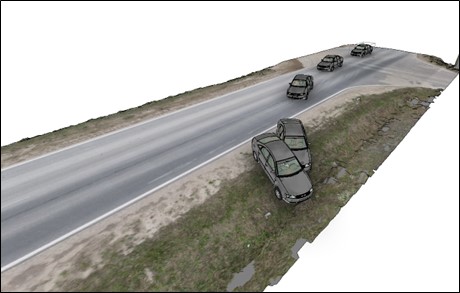
This study investigates the optimal photo overlap for documenting and reconstructing road accident sites using drone imagery. While a general recommendation for drone imagery overlap stands at 60–80%, this research aims to determine the minimum acceptable overlap required to generate a precise 3D point cloud suitable for forensic road accident simulation. A DJI Mavic Air 2 drone captured images at 2-meter intervals over a junction and a connecting road segment from varying altitudes, following the same flight path. The experiment systematically excluded images from the original dataset, processing photo sets taken at 2, 4, 6, 8, and 10-meter intervals. The corresponding point clouds were evaluated for accuracy and fragmentation. Comparisons were made regarding the number of images, the size of image sets and processing times. Additionally, 3D mesh surfaces were generated in the Virtual Crash software, and their quality was assessed. Results revealed that a 50% overlap was adequate for generating satisfactory 3D simulation environments, thereby reducing size of the raw data, the point cloud and processing time considerably. This finding is significant for forensic experts seeking efficient methods of road accident scene reconstruction, emphasizing the practicality of lower photo overlap in such scenarios.
References
Agisoft. (2022). Metashape Python Reference. Release 2.0.0. URL: https://www.agisoft.com/pdf/metashape_python_api_2_0_0.pdf
Agisoft. (2023). Agisoft Metashape 2.0.1. URL: https://www.agisoft.com/features/professional-edition/
Autodesk. (n.d.a). 3DS Max. URL: https://www.autodesk.com/products/3ds-max/overview?term=1-YEAR&tab=subscription
Autodesk. (n.d.b). Autodesk Maya software. URL: https://www.autodesk.com/products/maya/overview?term=1-YEAR&tab=subscription
Bisio, I., Garibotto, C., Haleem, H., Lavagetto, F., Sciarrone, A. (2022). A Systematic Review of Drone Based Road Traffic Monitoring System. IEEE Access. 10, 101537-101555. DOI: https://doi.org/10.1109/ACCESS.2022.3207282
Bupathy, P., Sivanpillai, R., Sajithvariyar, V., Sowmya, V. (2021). Optimizing low-cost UAV aerial image mosaicing for crop growth monitoring. The International Archives of the Photogrammetry, Remote Sensing and Spatial Information Sciences. XLIV-M-3-2021. URL: https://isprs-archives.copernicus.org/articles/XLIV-M-3-2021/7/2021/isprs-archives-XLIV-M-3-2021-7-2021.pdf
Castro, J., Morales-Rueda, F., Alcaraz-Segura, D., Tabik, S. (2023). Forest restoration is more than firing seeds from a drone. Restoration Ecology. 31(1), e13736. DOI: https://doi.org/10.1111/rec.13736
Charton, K., Sclater, V., Menges, E. (2021). Mapping spatially explicit vegetation gaps in Florida rosemary scrub using unmanned aerial vehicles. Ecosphere. 12(4). DOI: https://doi.org/10.1002/ecs2.3470
Virtual Crash (n.d.). Virtual Crash 5 Accident Reconstruction Software. URL: https://www.vcrashusa.com/vc5
Dandois, J., Olano, M., Ellis, E. (2015). Optimal altitude, overlap, and weather conditions for computer vision UAV estimates of forest structure. Remote Sensing. 7(10), 13895-13920. DOI: https://doi.org/10.3390/rs71013895
Desai, J., Mathew, J. K., Zhang, Y., Hainje, R., Horton, D., Hasheminasab, S. M., Habib, A., Bullock, D. M. (2022). Assessment of Indiana Unmanned Aerial System Crash Scene Mapping Program. Drones. 6(259), 1-15. DOI: https://doi.org/10.3390/drones6090259
DJI. (n.d.). Mavic Air 2. URL: https://www.dji.com/hu/mavic-air-2/specs
Domingo, D., Ørka, H., Næsset, E., Kachamba, D., Gobakken, T. (2019). Effects of UAV Image Resolution, Camera Type, and Image Overlap on Accuracy of Biomass Predictions in a Tropical Woodland. Remote Sensing. 11(8), 948. DOI: https://doi.org/10.3390/rs11080948
El Hoummaidi, L. L. (2021). Using unmanned aerial systems and deep learning for agriculture mapping. Heliyon. 7, e08154. DOI: https://doi.org/10.1016/j.heliyon.2021.e08154
Elhadary, A., Rabah, M., Ghanim, E., Mohie, R., Taha, A. (2022). The influence of flight height and overlap on UAV imagery over featureless surfaces and constructing formulas predicting the geometrical accuracy. NRIAG Journal of Astronomy and Geophysics. 11(1), 210–223. DOI: https://doi.org/10.1080/20909977.2022.2057148
Flores-de-Santiago, F., Valderrama-Landeros, L., Rodríguez-Sobreyra, R. (2020). Assessing the effect of flight altitude and overlap on orthoimage generation for UAV estimates of coastal wetlands. Journal of Coastal Conservation. 24, 35. DOI: https://doi.org/10.1007/s11852-020-00753-9
Blender (n.d.). Blender. URL: https://www.blender.org/download/
Gonçalves, G., Gonçalves, D., Gómez-Gutiérrez, Á., Andriolo, U., Pérez-Alvárez, J. (2021). 3D reconstruction of coastal cliffs from fixed-wing and multi-rotor uas: impact of SfM-MVS processing parameters, image redundancy and acquisition geometry. Remote Sensing. 13(6), 1222. DOI: https://doi.org/10.3390/rs13061222
Grohmann, C. H., Viana, C. D., Garcia, G. P., Albuquerque, R. W. (2023). Remotely piloted aircraft‐based automated vertical surface survey. MethodsX. 10. DOI: https://doi.org/10.1016/j.mex.2022.101982
James, M. R., Antoniazza, G., Robson, S., Lane, S. N. (2020). Mitigating systematic error in topographic models for geomorphic change detection: accuracy, precision and considerations beyond off-nadir imagery. Earth Surface Processes and Landforms. 45, 2251–2271. DOI: https://doi.org/10.1002/esp.4878
Lee, S., Park, J., Choi, E., Kim, D. (2021). Factors Influencing the Accuracy of Shallow Snow Depth Measured Using UAV-Based Photogrammetry. Remote Sensing. 13(4), 828. DOI: https://doi.org/10.3390/rs13040828
Litchi. (2023). Litchi for DJI Drones. URL: https://flylitchi.com/
Liu, X., Lian, X., Yang, W., Wang, F., Han, Y., Zhang, Y. (2022). Accuracy Assessment of a UAV Direct Georeferencing Method and Impact of the Configuration of Ground Control Points. Drones. 6(2), 30. DOI: https://doi.org/10.3390/drones6020030
Luis-Ruiz, J., Sedano-Cibrián, J., Pereda-García, R., Pérez-Álvarez, R., Malagón-Picón, B. (2021). Optimization of Photogrammetric Flights with UAVs for the Metric Virtualization of Archaeological Sites. Application to Juliobriga (Cantabria, Spain). Applied Sciences. 11(3), 1204. DOI: https://doi.org/10.3390/app11031204
Mat Amin, A., Abdullah, A., Abdul Mukti, S., Moht Zaidi, M., Tahar, K. (2020). Reconstruction of 3D accident scene from multirotor UAV platform. The International Archives of the Photogrammetry Remote Sensing and Spatial Information Sciences. XLIII-B2-2020, pp. 451–458. DOI: https://doi.org/10.5194/isprs-archives-XLIII-B2-2020-451-2020
Michail, A. L. (2024). A comprehensive review of unmanned aerial vehicle-based approaches to support photovoltaic plant diagnosis. Heliyon. 10, e23983. DOI: https://doi.org/10.1016/j.heliyon.2024.e23983
Nomikos, N., Gkonis, P. K, Bithas, P. S., Trakadas, P. (2023). A Survey on UAV-aided maritime communications: Deployment considerations, applications, and future challenges. IEEE Open Journal of the Communications Society. 4, 56–78. DOI: https://doi.org/10.1109/OJCOMS.2022.3225590
Nesbit, P. R., Hugenholtz, C. H. (2019). Enhancing UAV–SfM 3D model accuracy in high-relief landscapes by incorporating oblique images. Remote Sensing. 11(3), 239. DOI: https://doi.org/10.3390/rs11030239
Pádua, L., Sousa, J., Vanko, J., Hruška, J., Adão, T., Peres, E., Soua, A., Sousa, J. J. (2020). Digital reconstitution of road traffic accidents: A flexible methodology relying on UAV surveying and complementary strategies to support multiple scenarios. International Journal of Environmental Research and Public Health. 17(6). DOI: https://doi.org/10.3390/ijerph17061868
Pérez, J. A., Gonçalves, G. R., Morillo Barragán, J. R., Fuentes Ortega, P., Caracol Palomo, A. A. (2024). Low-cost tools for virtual reconstruction of traffic. Heliyon. 10, e29709. DOI: https://doi.org/10.1016/j.heliyon.2024.e29709
Sadeq, H. A. (2019). Accuracy assessment using different UAV image overlaps. Journal of Unmanned Vehicle Systems. 7(3), 175–193. DOI: https://doi.org/10.1139/juvs-2018-0014
Sanz-Ablanedo, E., Chandler, J. H., Ballestros-Pérez, P., Rodriguez-Pérez, J. R. (2020). Reducing systematic dome errors in digital elevation models through better UAV flight design. Earth Surface Processes and Landforms. 45(9), 2143-2147. DOI: https://doi.org/10.1002/ESP.4871
Seifert, E., Seifert, S., Vogt, H., Drew, D., van Aardt, J., Kunneke, A., Seifert, T. (2019). Influence of drone altitude, image overlap, and optical sensor resolution on multi-view reconstruction of forest images. Remote Sensing. 11(10), 1252. DOI: https://doi.org/10.3390/rs11101252
Singh, K. K., Frazier, A. E. (2018). A meta-analysis and review of unmanned aircraft system (UAS) imagery for terrestrial applications. International Journal of Remote Sensing. 39(15–16), 5078-5098. DOI: https://doi.org/10.1080/01431161.2017.1420941
Stott, E., Williams, R. D., Hoey, T. B. (2020). Ground control point distribution for accurate kilometre-scale topographic mapping using an RTK-GNSS unmanned aerial vehicle and SfM photogrammetry. Drones. 4(3), 55. DOI: https://doi.org/10.3390/drones4030055
Torres-Sánchez, J., López-Granados, F., Bprra-Serrano, I., Peña. (2018). Assessing UAV-collected image overlap influence. Precision Agriculture. 19, 115–133. DOI: https://doi.org/10.1007/s11119-017-9502-0
Török, Á., Bögöly, G., Somogyi, Á., Lovas, T. (2020). Application of UAV in topographic modelling and structural geological mapping of quarries and their surroundings – delineation of fault-bordered raw material reserves. Sensors. 20. DOI: https://doi.org/10.3390/s20020489
Wang, F., Zou, Y., Del Rey Castillo, E., Lim, J. P. (2022). Optimal UAV image overlap for photogrammetric 3D reconstruction of bridges. IOP Conference Series: Earth and Environmental Science. 1101, 022052. DOI: https://doi.org/10.1088/1755-1315/1101/2/022052
Young, D. J., Koontz, M., Weeks, J. (2022). Optimizing aerial imagery collection and processing parameters for drone-based individual tree mapping in structurally complex conifer forests. Methods in Ecology and Evolution. 13(7), 1447–1463. DOI: https://doi.org/10.1111/2041-210X.13860
Zulkifli, M. H., Tahar, K. N. (2023). The Influence of UAV Altitudes and Flight Techniques in 3D Reconstruction Mapping. Drones. 7(4), 227. DOI: https://doi.org/10.3390/drones7040227